En contournant le parc par le nord et en prenant plein est. On arrive à rejoindre le tracé du chemin de fer et la vieille piste du Ghan vers Maryvale et Finke


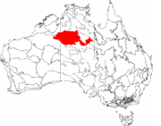


The Tanami Road, also known as the Tanami Track and the McGuire Track, is a road in Australia following a cattle droving route northwest from the MacDonnell Ranges area of central Australia just north of Alice Springs to Halls Creek in the Kimberley.
The Tanami Road is the most direct route from Alice Springs to the Kimberley, passing through the Tanami Desert. Along its route are Yuendumu and the Granites Mine owned by Newmont Mining. In the Northern Territory it passes through land owned by the Aboriginal Warlpiri Nation, and in Western Australia it passes through pastoral land.
The track is a graded, dirt road and although navigable by two-wheel drive vehicles, a four-wheel drive is recommended. Some parts of the road are prone to severe corrugations, making for an uncomfortable and slow drive at times. The only mid-way refueling point, Rabbit Flat, is only open Thursday through Sunday and so planning for this journey must take this into account.[1] Other reports state Rabbit Flat is open 7 days a week but recommend verifying by phone nevertheless.[2] Located 206 km from Alice Springs between Alice Springs and Rabbit Flat, Tilmouth Well provides fuel service 7 days a week.[2] Carrying adequate fuel and water supplies is essential.
Le cratère de Wolfe Creek ou cratère de la rivière Wolfe est un cratère météoritique se situant au cœur du parc national du cratère de Wolfe Creek dans l'État d’Australie-Occidentale[1][2]. Il est situé à 105 km au sud de la ville de Halls Creek[3].
Le cratère mesure 875 m de diamètre et encore 60 m de profondeur[3]. L’impact serait dû à une météorite d’environ 50 000 kg qui serait tombée il y a moins de 300 000 ans au Pléistocène[2].
Le peuple aborigène local Jaru (prononcer Djaru) le nomme Kandimalal[3].
Le cratère a été découvert au cours d'un survol aérien topographique en 1947; il fut exploré deux mois plus tard et sa découverte fut publiée en 1949[4]. Il doit son nom à une rivière qui passe à proximité, rivière qui doit elle-même son nom au prospecteeur et commerçant Robert Wolfe qui est le fondateur de la ville de Halls Creek au moment de la ruée vers l'or[5].
Le cratère a été décrit dans le film d'horreur Wolf Creek, citant notamment l’activité électromagnétique peu commune dans ses abords. Des panneaux à proximité du cratère mettent en garde les visiteurs sur les risques liés à la nature instable et glissante du terrain.


Wolfe Creek is a meteorite impact crater (astrobleme) in Western Australia.[1],[2] It is accessed via the Tanami Road 105 km south of the town of Halls Creek. The crater is central to the Wolfe Creek Meteorite Crater National Park.[3]
The crater averages about 875 metres in diameter, 60 metres from rim to present crater floor and it is estimated that the meteorite that formed it had a mass of about 50,000 kg[3], while the age is estimated to be less than 300,000 years (Pleistocene).[2]
The local Djaru (Jaru) Aboriginal people know it as Kandimalal.[3] It was brought to the attention of science after being spotted during an aerial survey in 1947, investigated on the ground two months later, and reported in publication in 1949.[4] The European name for the crater comes from a nearby creek, which was in turn named after Robert Wolfe (early reports misspell the name as Wolf Creek), a prospector and storekeeper during the gold rush that established the town of Halls Creek.[5]


Le Parc national de Purnululu (239 723 ha), situé dans l’État d’Australie occidentale, contient le massif très découpé des Bungle Bungle, composé de grès quartzique du dévonien érodé pendant 20 millions d’années. Il en reste un ensemble de tourelles et de cônes en forme de ruches aux flancs abrupts, à la surface striée de bandes horizontales de croûte gris foncé de cyanobactéries (organismes photosynthétiques unicellulaires). Ces exemples exceptionnels de karst à cônes de grès doivent leur existence et leur caractère unique à l’interaction de plusieurs phénomènes géologiques, biologiques, climatiques et de l’érosion.


